Your rank among every aspirant in India, the moment you submit.
- State rank
- Percentile
- Weak areas
UPSC Battleground
Write the paper. Get your All-India Rank the moment you submit.
No sign-up · Your name goes on the All-India leaderboard
- 44 questions
- 150 minutes
- 284 marks
Instructions
50 questions on Lower Palaeolithic sites, stone tools, Bhimbetka, the Himalayas and Toba.
Drag the right date to the Bronze Age line.
Drag each picture onto a circle, or tap a picture and then a circle. Tap a placed picture to take it back.

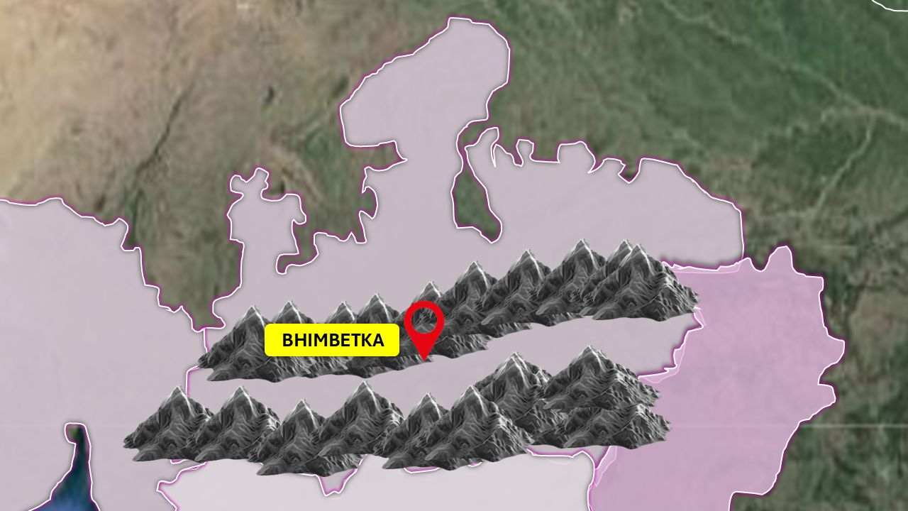
The rivers have been removed from this map. Draw the course of the Narmada from its source in the east to the sea in the west.
The Narmada flows west between the Vindhya (north) and Satpura (south) ranges.
Marked out of 10 after Final Submit by comparing your route with the correct one.
Why was Pahalgam occupied again and again in prehistory? Explain with a labelled sketch of its setting. (150 words)
Write on paper and upload clear photos.
This answer expects diagrams. Typed answers cannot earn diagram marks — upload photos of your handwritten answer to get them.
Up to 8 pages, in order. Write clearly and keep diagrams inside the frame.
Marked out of 10 by AI after Final Submit. If you fill both tabs, the tab that is open when you submit is used.
Put each rock in its group.
Drag each card into a box, or tap a card and then tap a box. Leave a card out if you are not sure.
Pahalgam
Mark each statement TRUE or FALSE. Leave it blank if you are not sure. Tap your choice again to clear it.
- The Lidder River flows through Pahalgam and joins the Jhelum.
- The Lower Palaeolithic occupation at Pahalgam is linked with Homo sapiens.
- Scrapers and borers found there suggest later phases of occupation too.
- The Overa-Aru Wildlife Sanctuary is part of the Palaeolithic site itself.
- Layers holding material from different periods make a site stratified.
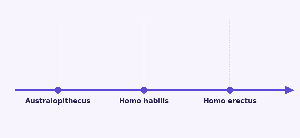
Drag in only what the lecture links with Homo erectus.
Drag the names that were contemporaries onto the centre, or tap a name to move it in or out.
Match the site with its river
Drag the Column B cards up or down until each one sits next to its match. On a phone, tap two cards to swap them.
One shot per round: aim and click the right word on the shelf. There is no hit or miss shown — your marks appear after Final Submit.
ALL SHOTS FIRED
Lower Palaeolithic sites are rare in the Indo-Gangetic Plains. Does this mean early humans never lived there? Discuss. (250 words)
Marked out of 10 by AI after Final Submit. No negative marking.
Drag each name under its tool.
Drag each picture onto a circle, or tap a picture and then a circle. Tap a placed picture to take it back.

Write these regions in their places on the map: Himalayas, Indo-Gangetic Plains, Thar Desert, Aravalli, Satpura & Vindhya, Peninsular Plateau, Western Ghats, Eastern Ghats and both Coastal Plains.
Short names are fine.
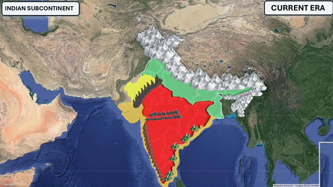
Marked out of 10 by AI after Final Submit.
Using a flowchart, explain how a supervolcanic eruption such as Toba could have affected early humans. (150 words)
Draw on paper and upload clear photos.
This answer expects diagrams. Typed answers cannot earn diagram marks — upload photos of your handwritten answer to get them.
Up to 8 pages, in order. Write clearly and keep diagrams inside the frame.
Marked out of 10 by AI after Final Submit. If you fill both tabs, the tab that is open when you submit is used.
Sort these sites as the lecture describes them.
Drag each card into a box, or tap a card and then tap a box. Leave a card out if you are not sure.
Pigments and art
Mark each statement TRUE or FALSE. Leave it blank if you are not sure. Tap your choice again to clear it.
- Red pigment was commonly made from hematite, an iron oxide.
- White pigment could be made from limestone (calcium carbonate).
- Blue is common in prehistoric Indian rock art because lapis lazuli was found everywhere in India.
- Black pigment could come from charcoal or manganese dioxide.
- Warli artists traditionally paint with a white rice paste.
Drag in the Lower Palaeolithic sites of Karnataka.
Drag the names that were contemporaries onto the centre, or tap a name to move it in or out.
Match the site with its district
Drag the Column B cards up or down until each one sits next to its match. On a phone, tap two cards to swap them.
How did geography shape the difference between the Sonian and Madrasian stone-tool traditions? (150 words)
Marked out of 10 by AI after Final Submit. No negative marking.
Drag each tool picture to the hominin the lecture links it with.
Drag each picture onto a circle, or tap a picture and then a circle. Tap a placed picture to take it back.
From sand to tool stone
Draw a flowchart showing how sand becomes sandstone and then quartzite, and show where rock shelters and stone tools fit in.
Draw and label your diagram. Marked out of 10 by AI after Final Submit.
With the help of a labelled diagram, explain how chert forms in the limestone of the Rohri Hills and why it was valued for tools. (150 words)
Draw on paper and upload clear photos.
This answer expects diagrams. Typed answers cannot earn diagram marks — upload photos of your handwritten answer to get them.
Up to 8 pages, in order. Write clearly and keep diagrams inside the frame.
Marked out of 10 by AI after Final Submit. If you fill both tabs, the tab that is open when you submit is used.
At Pahalgam and Isampur, which tools belong to the Lower Palaeolithic and which to later periods?
Drag each card into a box, or tap a card and then tap a box. Leave a card out if you are not sure.
Bhimbetka’s paintings
Mark each statement TRUE or FALSE. Leave it blank if you are not sure. Tap your choice again to clear it.
- The earliest paintings discussed belong to the Upper Palaeolithic.
- Dancing scenes become an important theme in the Mesolithic paintings.
- In the Boar Rock painting the animal is drawn smaller than the humans.
- The lecture places the arrival of horses in India around 1600–1000 BCE.
- A newer painting made over an older one is called stratification.
Drag in only the prehistoric painting sites named in the lecture.
Drag the names that were contemporaries onto the centre, or tap a name to move it in or out.
Match the person with the work
Drag the Column B cards up or down until each one sits next to its match. On a phone, tap two cards to swap them.
Drag each event to its date (years ago).
Drag each picture onto a circle, or tap a picture and then a circle. Tap a placed picture to take it back.

Explain the geographical and geological factors behind the long human occupation of Bhimbetka. (250 words)
Marked out of 10 by AI after Final Submit. No negative marking.
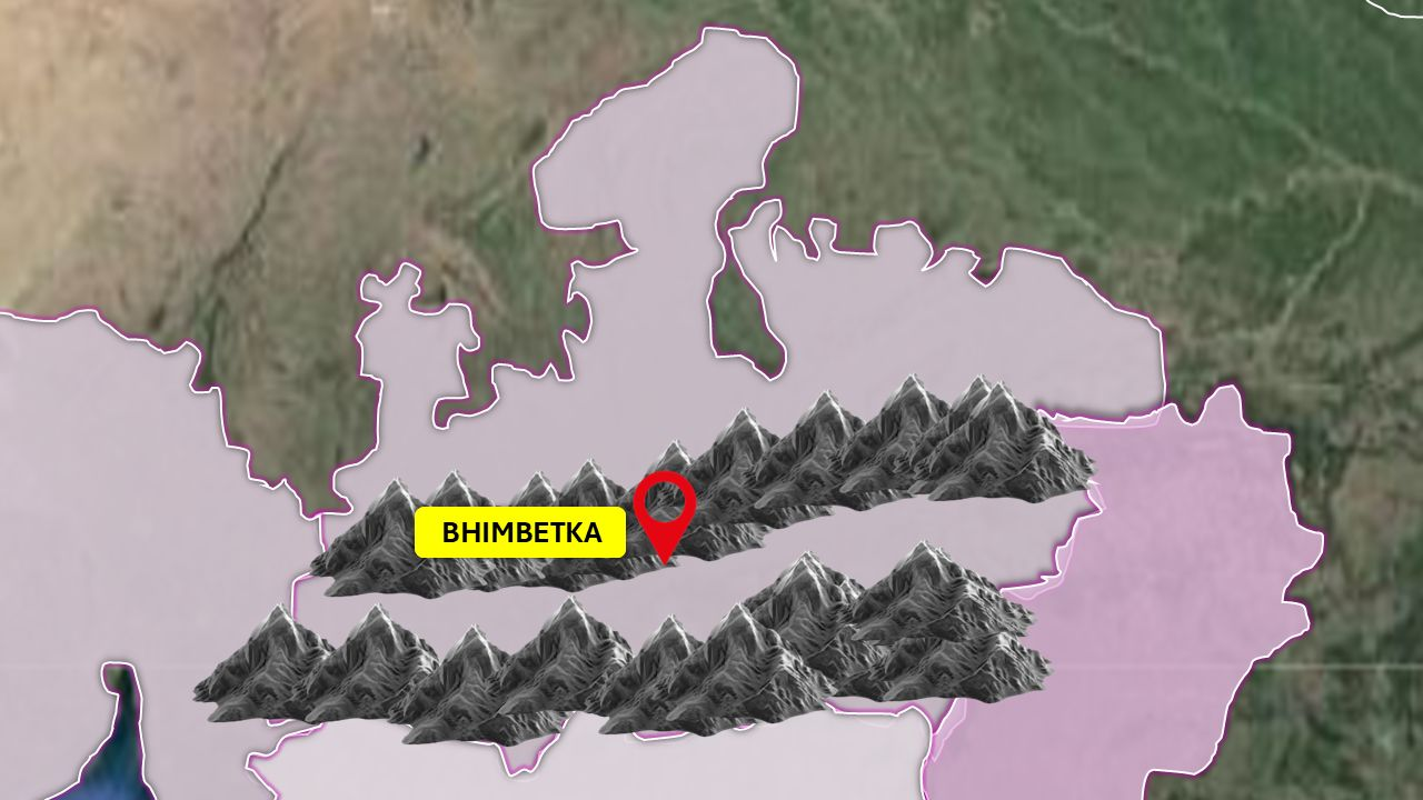
Drag each range and river to its place on the map.
Drag each picture onto a circle, or tap a picture and then a circle. Tap a placed picture to take it back.

On the same map, draw the course of the Tapti (Tapi) River to the sea.
The Tapti flows west, south of the Satpura Range.
Marked out of 10 after Final Submit by comparing your route with the correct one.
Drag the two labels to their places.
Drag each picture onto a circle, or tap a picture and then a circle. Tap a placed picture to take it back.
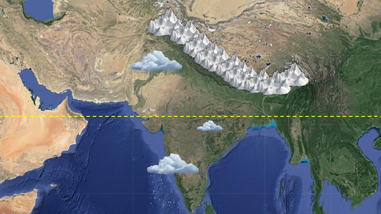
What clues do archaeologists use to locate Lower Palaeolithic sites? Illustrate with a sketch. (150 words)
Write on paper and upload clear photos.
This answer expects diagrams. Typed answers cannot earn diagram marks — upload photos of your handwritten answer to get them.
Up to 8 pages, in order. Write clearly and keep diagrams inside the frame.
Marked out of 10 by AI after Final Submit. If you fill both tabs, the tab that is open when you submit is used.
Drag each region to its place on the map.
Drag each picture onto a circle, or tap a picture and then a circle. Tap a placed picture to take it back.

Homo erectus
Mark each statement TRUE or FALSE. Leave it blank if you are not sure. Tap your choice again to clear it.
- The source places the appearance of Homo erectus at about 1.9 million years ago.
- Its brain size is given as roughly 850–1,000 cubic centimetres.
- Homo erectus is strongly associated with Acheulean tools.
- Showing Homo erectus beside a modern tiger is chronologically accurate.
- Homo erectus is the species to which modern humans belong.
Drag each name onto its stone.
Drag each picture onto a circle, or tap a picture and then a circle. Tap a placed picture to take it back.

How a rock shelter forms
Draw three stages showing how a natural rock shelter like those at Bhimbetka forms in sandstone.
Draw and label your diagram. Marked out of 10 by AI after Final Submit.
Drag each tradition onto its red circle.
Drag each picture onto a circle, or tap a picture and then a circle. Tap a placed picture to take it back.

Draw the route by which Homo erectus moved out of Africa to reach India, as described in the lecture.
Start in East Africa; cross the Arabian region; pass Iraq, Iran and Pakistan; end in India.
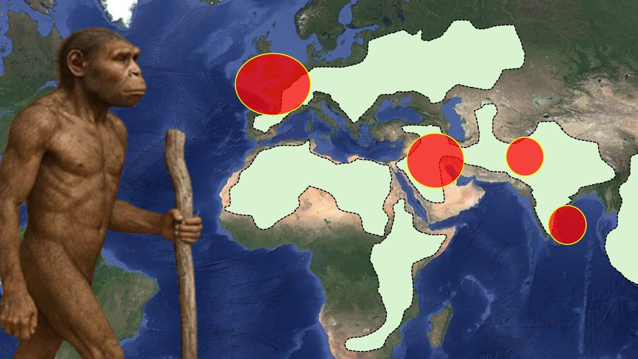
Marked out of 10 after Final Submit by comparing your route with the correct one.
Drag each eruption date beside its ash layer.
Drag each picture onto a circle, or tap a picture and then a circle. Tap a placed picture to take it back.

Sonian tool vs Madrasian hand axe
Draw a Sonian pebble tool and a Madrasian hand axe side by side. Label the worked edge and the smooth grip on the Sonian tool, and the almond shape on the Madrasian one.
Draw and label your diagram. Marked out of 10 by AI after Final Submit.
Drag the range and the river to their places.
Drag each picture onto a circle, or tap a picture and then a circle. Tap a placed picture to take it back.

Locating Pahalgam
Draw a simple schematic map showing the Zanskar Range, the Lidder River joining the Jhelum, the Jhelum joining the Indus system, and mark Pahalgam.
Draw and label your diagram. Marked out of 10 by AI after Final Submit.
Drag each division onto its belt.
Drag each picture onto a circle, or tap a picture and then a circle. Tap a placed picture to take it back.

That's the end of the paper. Check your answers, then submit.
Submit the paper?
Marking your answers
Saving your answers…
Please keep this page open. Written answers take a few seconds each.